Altis: Difference between revisions
m (added image and some text) |
mNo edit summary |
||
| Line 1: | Line 1: | ||
[[File:A3_Altis_birdView.jpg|400px|right]] | [[File:A3_Altis_birdView.jpg|400px|right]] | ||
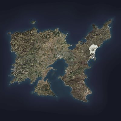
'''Altis''' is an Arma 3 terrain, released with the game. It is a north aegean mediterranean island with an area of 268.65 km<sup>2</sup> and is a 0.75x scale copy of Limnos. It has a mediterranean flora and north aegean geology. The island is %montanious and a lot of delta. The capital is Pyrgos, succeeding Kavala. It consists of 32 towns. | |||
__TOC__ | |||
== Geography == | |||
The island geologically has volcanic north mediterranean properties. There are multiple pine forests scattered around the landscape. There is also a very small desert, just north of thetown of Abdera. | |||
There are 3 seasonal lakes that are all flooded in all seasons except summer, Limni, Ochrolimni and Almyra. In summer, they are completely dry with hard and cracked surfaces. Limni is used as an airfield during the summer thanks to its salt and hard surface properties. | |||
The coastline is surrounded by 20 bays. Outside of the bays, the coastline mostly shows rocks and cliffs, with very little number of beaches. | |||
The highest point in the island is the Thronos hill, with an altitude of 350m. | |||
[[Category:Arma 3: Islands]] | [[Category:Arma 3: Islands]] | ||
Revision as of 15:26, 16 December 2018
Altis is an Arma 3 terrain, released with the game. It is a north aegean mediterranean island with an area of 268.65 km2 and is a 0.75x scale copy of Limnos. It has a mediterranean flora and north aegean geology. The island is %montanious and a lot of delta. The capital is Pyrgos, succeeding Kavala. It consists of 32 towns.
Geography
The island geologically has volcanic north mediterranean properties. There are multiple pine forests scattered around the landscape. There is also a very small desert, just north of thetown of Abdera.
There are 3 seasonal lakes that are all flooded in all seasons except summer, Limni, Ochrolimni and Almyra. In summer, they are completely dry with hard and cracked surfaces. Limni is used as an airfield during the summer thanks to its salt and hard surface properties.
The coastline is surrounded by 20 bays. Outside of the bays, the coastline mostly shows rocks and cliffs, with very little number of beaches.
The highest point in the island is the Thronos hill, with an altitude of 350m.
