Terrain Tutorial – Arma 2
No edit summary |
No edit summary |
||
| Line 26: | Line 26: | ||
** ''5: All tools should be installed now in respective directory ('''O:\BIS TOOLS 2\'''). Every Tool is stored in its own folder. | ** ''5: All tools should be installed now in respective directory ('''O:\BIS TOOLS 2\'''). Every Tool is stored in its own folder. | ||
[[Image:Tutorial_tool_install_2.jpg]] | [[Image:Tutorial_tool_install_2.jpg]] | ||
*xp home users-- a P partition will be auto created where then *after you can make a BIS 2 TOOLS folder with the 8 tools manually moved to this folder. An Armawork folder should have auto installed in your my documents also. | |||
*** [http://www.youtube.com/watch?v=m9rpAbC0pPM Video Tutorial : Setup Editing Tools 2] | *** [http://www.youtube.com/watch?v=m9rpAbC0pPM Video Tutorial : Setup Editing Tools 2] | ||
Revision as of 22:00, 1 December 2009
Introduction
This simple learning by doing tutorial will explain the basic process of creating a Island in ArmA2.
What the tutorial will deal with:
- Setup Editing Tools 2
- Preparing the Working folder
- Setup Visitor & The Landscape
- Binarizing your world properly.
- Adding Objects
- Add more Surfaces
Part 1
Setup Editing Tools 2
- It´s pretty important to choose a proper place to install the BI Editing tools 2 before starting with anythings else (a clean empty partition is highly recommended).
- In this tutorial we will use Partition O:\
- 1: Download the BI Editing Tools 2
- 2: Create a folder called BIS TOOLS 2 in your designated Partition (O:\BIS TOOLS 2\ in our example)
- 3: Open or extract the dowloaded zip file and start the BI_Editing_Tools_2_Setup.exe
- 4: The installer is basically self explanatory, the actual important process is to change the directory for each tool.
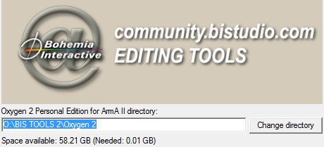
- Make sure to define the respective path for each tool (e.g.: O:\BIS TOOLS 2\Oxygen 2, O:\BIS TOOLS 2\Visitor 3 .....and so on).
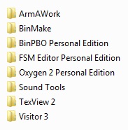
- 5: All tools should be installed now in respective directory (O:\BIS TOOLS 2\). Every Tool is stored in its own folder.
- xp home users-- a P partition will be auto created where then *after you can make a BIS 2 TOOLS folder with the 8 tools manually moved to this folder. An Armawork folder should have auto installed in your my documents also.
Preparing the Working folder
- A virtual drive (P:) will be emulated automatically while installtion process of the tools.
- This is actually just a association of the O:\BI TOOLS 2\ArmAWork\ folder in our example.
- One should think about which objects one would like to use on the map. For basic understanding we keep the amount of used objects pretty low, to avoiding loosing the overlook.
- Drive P: already contains the ca folder which fruther contains a couple of unpacked pbo files and another folder called Roads2.
Setup
- 1: Go to P:\CA\ and create a new folder called plants2.
- 2: Browse to your ArmA2 main directory/Addons folder and unpack the plants2_bush, plants2_clutter, plants2_misc, plants2_tree .pbo's
- How to Extract Pbo files?
- Dowload the latest Versions of ExtractPbo and DePbo by Mikero at DevHeaven
- Extract them right into our Tutorial partition O:\ComTools\ExtractPbo.....
- Move the DePbo.dll from the dowloaded DePbo into the ..Windows\System32 folder (as explained in the readme.DePbo.txt)
- Rightclick on a *.pbo and choose Open with, then point to the ExtractPbo\ExtractPbo.exe and mark the checkbox to always open this filetype with ExtractPbo.exe.
- Now each time you unpack a *.pbo by doubleclick you´ll recieve a clean unpacked file with *.p3ds, config.cpp and all other stuff from the pbo.
- There are of course much further ways to extract pbos and unrap config.bin's but this is a very conformable one.
- 3: Rename this extracted folders by removing "plants2_" of the name.
- 4: Cut&Paste the bush, clutter, misc and tree folders to the new created P:\CA\plants2\ folder.
- 5: Do the same with the building2.pbo. This time you dont need to rename anythings.
- 6: Now extract the Ca.pbo but only Cut&Paste the stuff inside the extracted Ca.pbo to P:\CA\
- You can do this with all other pbos but for this tutorial we are only using building2&plants2.
- 7: When it´s done so your P:\CA\ should look as shown in the picture below.
Your Project folder
- 1: Now you can create a own project Folder in your P:\ drive. Optimal would be P:\TAG\ name or an other short identification\namespace.
- In this Tutorial we will use as our Namespace P:\TUT
- 2: Following now a quite important part where we make sure that we have working animations/ladders on our Terrain. For that we need the respective config files from each Object which we´re about to use within our terrain.
- 3: To do that we can easy create a small bat or use the windows command line: Navigate to the P:\ca folder and
- 4: Run the following dos command: xcopy *.cpp P:\<YourNamespace>\ca\ /S /Y Or manually move the cpps with the correct folder structur to your namespace
- If your not familiar with cmd then put this copy_cpp.bat in your P:\CA\ foldier and run it.
- This command creates a duplicate set of '\ca' folders under your namespace and copies only the config.cpp files to each subfolder.
- Read more about that in Synides Great Tutorial ArmA_Build_Environment_Setup
Setup Visitor
This Part of the Tutorial is still work in Progress
- 1: Dowload the Tutorial Sample Map and extract it to our P:\TUT\ folder so it will look like P:\TUT\TUT_SampleMap
- 2: Run the O:\BI TOOLS 2\Visitor 3\Visitor3.exe
- 3: Open Tools -> SystemPreferences and check if all pathes are correct
Start with our Project
- 1: Open Project -> New (or press Ctrl+N)
- 2: In the next Project parameters window select the values for:
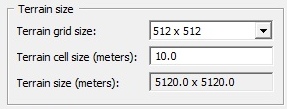
- Terrain grid size 512x512
- Terrain cell size 10
- detailed informations about the Project Parameters can be read in the Visitor 3 Manual
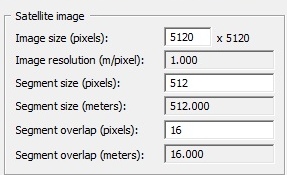
- 3: Go to Tools -> Project parameters and open the Calculator and put in Image Size (Pixels): 5120. Hit apply and close only the Calculator
- 4: Open Tools -> ProjectPreferences and enter the path to your data folder (Textures): P:\TUT\TUT_SampleMap\Data\. Click ok and close.
- 5: In the Project parameters window click on Base (active) and press the Edit Button. Choose 40x40m Texture size. Apply and close the Project parameters window
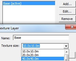
Import Terrain
- 1: Go to Open -> Import Terrain from Picture and browse to P:\TUT\TUT_SampleMap\Source\terrain\terrain.pbl
- Be sure you set the view to elevation colour style (hit the 5th button from the left) to see the contours.
Save often saves you time and nerves
- Goto Poject -> SaveAs and save your map as TUT_SampleMap.pew (add .pew to your filename, otherwise vis will not recognosize the file)
Import Satellite & Mask
- 1: Go to Tools -> Import Satellite + Mask.. and browse to P:\TUT\TUT_SampleMap\Source\layer.cfg
- 2: Select text mode for saving the rvmats in the next window .
- 3: Visitor asks now for the Sat file so browse to P:\TUT\TUT_SampleMap\Source\sat_lco.png
- 4: Same with the Mask point it to P:\TUT\TUT_SampleMap\Source\mask_lco.png
- 5: The import process beginns right after you hit OK. That may take some minutes and Visitor might not respont untill process has finally finished.
- 6: Point the mouse somewhere in the middle of the map and hit the center mousebutton (wheel). A white square appears right at this position (point of view).
- 7: Start Buldozer via Project -> Connect to Buldozer (or hit the ! icon)
- 8: Buldozer converts the Textures automatically from png to paa (DOS window)
- 9: After the conversion process has finsished you should be able to see the landscape in buldozer. The textures will appear so more you zoom onto the surface.
- 10: Switch back to Visitor by hit Alt+Tab (dont close buldozer) and goto Project -> Export World and save it under P:\TUT\TUT_SampleMap\TUT_SampleMap.wrp
Binarizing your world properly
- 1: Start BinPbo O:\BIS TOOLS 2\BinPBO Personal Edition\BinPBO.exe.
- 2: Choose the P:\TUT\TUT_SampleMap in the addon/source directory field.
- 3: Now go to your ArmA2 Main folder and create a new folder called @TUT. Open this one and create another one which is called Addons (F:\Games\ArmA 2\@TUT\Addons).
- 4: Back in BinPbo we set F:\Games\ArmA 2\@TUT\Addons as destination directory.
- 5: Open the BinPbo options and remove *.wrp out of the list of files to copy directly
- 6: In the path of temporary folder we set P:\BIN_TEMP
- 7: Now remove the hook from use source path and enter p:\tut\
- 8: We are ready to binarize our Island. Close the options tab and click on Pack. That may take a while, wait until Ready appears at the bottom of BinPBO.
- 9: After BinPbo has finsihed you should see in your F:\Games\ArmA 2\@TUT\Addons\ folder the tut_samplemap.pbo and the logfile.
- 10: Add the @TUT Mod folder to your ArmA2.exe shortcut ("F:\Games\ArmA 2\arma2.exe" -mod=@TUT -window -nosplash) or use one of the meanwhile available ArmA2 launchers.
- Check out your map Ingame :-)
Part 2
Objects and Various Tips:
Terrain editing:
U will raise the height of a vertice slightly I will raise the height of the vertice greatly J will lower the height of a vertice slightly K will lower the height of a vertice greatly
About vertices:
You may have to hit F or G (i forget which) to show the arrow that goes to each centerpoint of a vertice. While moving the mouse around the map, you'll notice that the arrow cursor 'sticks' to the closest centerpoint of a vertice.
Think of a vertice as a hexagonial shape where you simply raise or lower the centerpoint of that shape. So, when you raise a vertice, it'll make a point upwards. Doing it repeatedly will make the point higher and 'sharper'. Therefore to make sure your terrain isn't too sharp, you'll have to raise the vertices around it as well.
Keep in mind also that editing vertices is pretty tedious, and it should really only be used for tweaking height.
Road networks do not act as objects, therefore you can only select, move, or budge them in Visitor 3. (thx to El Mariachi)

