Terrain Processor: Heightmap: ASCII DEM Convert: Difference between revisions
Jump to navigation
Jump to search
No edit summary |
Lou Montana (talk | contribs) m (Text replacement - "[[Image:" to "[[File:") |
||
| (One intermediate revision by the same user not shown) | |||
| Line 1: | Line 1: | ||
{{TerrainProcessorManual | |||
{{TerrainProcessorManual | |Heightmap: Create from Geodetic .asc|task= | ||
|Heightmap: Create from Geodetic .asc|= | |BITasksPlugin.dll|dll= | ||
|BITasksPlugin.dll|= | |None|geometry= | ||
|None|= | |Yes|heightMap= | ||
|Yes|= | |||
|DESCRIPTION=Algorithm creates UTM ASCII heightmap from geodetic .ASC digital elevation models. | |DESCRIPTION=Algorithm creates UTM ASCII heightmap from geodetic .ASC digital elevation models. | ||
[[ | [[File:TerrainProcessor_Heightmaps.png]] | ||
* <span style="color: rgb(255,153,0);"><strong>Orange</strong></span> - regular <strong>geodetic</strong> heightmap | * <span style="color: rgb(255,153,0);"><strong>Orange</strong></span> - regular <strong>geodetic</strong> heightmap | ||
* <span style="color: rgb(0,0,255);"><strong>Blue</strong></span> - new terrain <strong>UTM</strong> heightmap | * <span style="color: rgb(0,0,255);"><strong>Blue</strong></span> - new terrain <strong>UTM</strong> heightmap | ||
| Line 24: | Line 23: | ||
## Get height from geodetic ASCII heightmap with bi-cubic spline function. | ## Get height from geodetic ASCII heightmap with bi-cubic spline function. | ||
}} | }} | ||
[[Category:Terrain Processor Manual|Heightmap]] | |||
Latest revision as of 23:11, 20 November 2023
Task details
Task name : Heightmap: Create from Geodetic .asc
Dll plugin name : BITasksPlugin.dll
Geometry type : None
Heightmap : Yes
Description
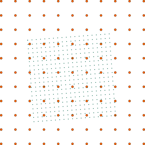
Algorithm creates UTM ASCII heightmap from geodetic .ASC digital elevation models.
- Orange - regular geodetic heightmap
- Blue - new terrain UTM heightmap
Task parameters
- Easting - UTM easting coordinate
- Northing - UTM northing coordinate
- Zone - UTM zone
- Hemisphere - UTM hemisphere (Northern, Southern)
- Rows & columns count - Rows and columns count
- Cell size - Cell size in meters.
Usage
Conversion tool, creating UTM heightmap from Geodetic heightmap.
Algorithm
- Load geodetic ASCII DEM.
- Prepare heightmap with size and position in UTM.
- For each cell in heightmap:
- Get its UTM coordinate
- Convert UTM coordinate to geodetic coordinate.
- Get height from geodetic ASCII heightmap with bi-cubic spline function.
