createLocation: Difference between revisions
Jump to navigation
Jump to search
(Added Mount misc) |
m ("thumbnailed" image) |
||
| Line 34: | Line 34: | ||
<dl class="command_description"> | <dl class="command_description"> | ||
<!-- Note Section BEGIN --> | <!-- Note Section BEGIN --> | ||
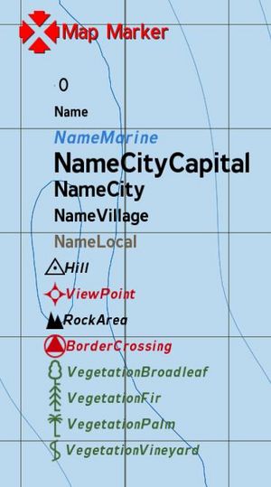
[[Image:LocationTypes.JPG|right]] | [[Image:LocationTypes.JPG|right|thumb|Location Types]] | ||
Here's all (?) CfgLocationTypes. First one (0) is Mount and is used for all elevation points on a map. --[[User:Doolittle|Doolittle]] 04:14, 29 November 2007 (CET) | Here's all (?) CfgLocationTypes. First one (0) is Mount and is used for all elevation points on a map. --[[User:Doolittle|Doolittle]] 04:14, 29 November 2007 (CET) | ||
<!-- Note Section END --> | <!-- Note Section END --> | ||
Revision as of 23:01, 26 January 2008
Description
- Description:
- Creates a location of the specified class and dimensions at the specified position. Classes are defined in CfgLocationTypes
- Groups:
- Uncategorised
Syntax
- Syntax:
- Location = createLocation ["ClassName", Position, sizeX, sizeY]
- Parameters:
- "ClassName" : String
- Position
- sizeX: Number in meters
- sizeY: Number in meters
- Return Value:
- Location
Examples
- Example 1:
myLocation = createLocation ["NameVillage", [4035,2151,10], 100, 100]
Additional Information
- See also:
- See also needed
Notes
-
Report bugs on the Feedback Tracker and/or discuss them on the Arma Discord or on the Forums.
Only post proven facts here! Add Note
Notes
Here's all (?) CfgLocationTypes. First one (0) is Mount and is used for all elevation points on a map. --Doolittle 04:14, 29 November 2007 (CET)
