Tanoa: Difference between revisions
No edit summary |
Lou Montana (talk | contribs) m (Text replacement - "{{arma3}}" to "{{GameCategory|arma3|link= y}}") |
||
| (22 intermediate revisions by 5 users not shown) | |||
| Line 1: | Line 1: | ||
[[ | [[File:A3_Tanoa_birdView.jpg|400px|right]] | ||
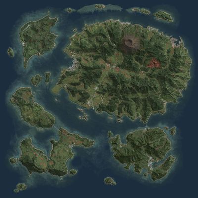
'''Tanoa''' is an {{GameCategory|arma3|link= y}} terrain, released in 11 July 2016 as a part of the [[Arma 3 Apex|Apex expansion]]. It is a South Pacific archipelago map, and it is 100 km<sup>2</sup> . It has a lush tropical flora, a very dense jungle, with a very rough and mountanious terrain. The archipelago also features a volcano in the main island, '''Mont Tanoa'''. The archipelago has a '''coral reef'''. | |||
== | == The Islands == | ||
=== Tanoa === | |||
==Trailer== | |||
The main and the largest island in the archipelago. The island has N number of towns and villages, the largest being '''Georgetown''', the capital of the archipelago. The island has two airfields, two ports, two military bases, a mine, a factory, two diesel powerplants, numerous lumberyards, 10 temples, and a large railway network, mostly covering the west side of the island. The island is largely industrialized, the main economic sources being lumber, sugar and mining. | |||
*http://arma3.com/tanoa | === Tuvanaka === | ||
*http://dev.arma3.com/post/sitrep-00111 | |||
*http://arma3.com/news/e3-2015-bohemia-interactive-reveals-terrain-for-upcoming-arma-3-expansion | The north-western island. It has two towns, '''Tuvanaka''' and '''Belfort'''. The island is mainy used for military purposes, as nearly 3/4 of the island has been claimed by the military base. The island has one airfield, two long rage transmitter antennas, a large training range and two small harbors, each in one town. | ||
=== Balavu === | |||
The northern South-west island. It consists of 7 towns, 3 harbors and a long range transmitter antenna. The largest town is '''Balavu'''. There is a bridge and a ferry route to the neighboring island, '''Katkoula'''. | |||
=== Katkoula === | |||
The southern south-west island. It consists of 6 towns, an airfield, two long range transmitter antennas and a small harbor. The largest town is Katkoula. | |||
=== Moddergat === | |||
The south-eastern island. It has 12 towns and villages, the largest being '''Lijnhaven'''. It has two harbors, a long range transmitter antenna, an airfield, and an old fortress. It is dutch speaking. It is connected to the main island with a bridge and a ferry route. | |||
== Trailer == | |||
{{Youtube|5aHxziH5l0g|Tanoa trailer|center|800}} | |||
== Links == | |||
* [[Arma 3 Apex]] | |||
* [https://www.youtube.com/watch?v{{=}}H0N0T_COJEA Arma 3 Tanoa terrain reveal - PC Gaming Show 2015 - YouTube] | |||
* {{Link|http://arma3.com/tanoa|Tanoa | Arma 3}} | |||
* {{Link|link= http://dev.arma3.com/post/sitrep-00111|text= SITREP #00111 | Dev Hub | Arma 3}} | |||
* {{Link|http://arma3.com/news/e3-2015-bohemia-interactive-reveals-terrain-for-upcoming-arma-3-expansion|E3 2015 - BOHEMIA INTERACTIVE REVEALS TERRAIN FOR UPCOMING ARMA 3 EXPANSION | Arma 3}} | |||
* {{Link|http://arma3.com/news/report-in-radim-vitek-petr-sedlacek-environment|REPORT IN: RADIM VITEK & PETR SEDLACEK - ENVIRONMENT | Arma 3}} | |||
{{GameCategory|arma3|Terrains}} | |||
Latest revision as of 13:00, 19 March 2024
Tanoa is an Arma 3 terrain, released in 11 July 2016 as a part of the Apex expansion. It is a South Pacific archipelago map, and it is 100 km2 . It has a lush tropical flora, a very dense jungle, with a very rough and mountanious terrain. The archipelago also features a volcano in the main island, Mont Tanoa. The archipelago has a coral reef.
The Islands
Tanoa
The main and the largest island in the archipelago. The island has N number of towns and villages, the largest being Georgetown, the capital of the archipelago. The island has two airfields, two ports, two military bases, a mine, a factory, two diesel powerplants, numerous lumberyards, 10 temples, and a large railway network, mostly covering the west side of the island. The island is largely industrialized, the main economic sources being lumber, sugar and mining.
Tuvanaka
The north-western island. It has two towns, Tuvanaka and Belfort. The island is mainy used for military purposes, as nearly 3/4 of the island has been claimed by the military base. The island has one airfield, two long rage transmitter antennas, a large training range and two small harbors, each in one town.
Balavu
The northern South-west island. It consists of 7 towns, 3 harbors and a long range transmitter antenna. The largest town is Balavu. There is a bridge and a ferry route to the neighboring island, Katkoula.
Katkoula
The southern south-west island. It consists of 6 towns, an airfield, two long range transmitter antennas and a small harbor. The largest town is Katkoula.
Moddergat
The south-eastern island. It has 12 towns and villages, the largest being Lijnhaven. It has two harbors, a long range transmitter antenna, an airfield, and an old fortress. It is dutch speaking. It is connected to the main island with a bridge and a ferry route.
Trailer
