createLocation: Difference between revisions
Jump to navigation
Jump to search
m ("thumbnailed" image) |
mNo edit summary |
||
| Line 35: | Line 35: | ||
<!-- Note Section BEGIN --> | <!-- Note Section BEGIN --> | ||
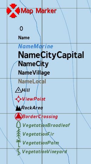
[[Image:LocationTypes.JPG|right|thumb|Location Types]] | [[Image:LocationTypes.JPG|right|thumb|Location Types]] | ||
Possible location types are: | |||
*Mount | |||
*Name | |||
*NameMarine | |||
*NameCityCapital | |||
*NameCity | |||
*NameVillage | |||
*NameLocal | |||
*Hill | |||
*ViewPoint | |||
*RockArea | |||
*BorderCrossing | |||
*VegetationBroadleaf | |||
*VegetationFir | |||
*VegetationPalm | |||
*VegetationVineyard | |||
<!-- Note Section END --> | <!-- Note Section END --> | ||
</dl> | </dl> | ||
Revision as of 22:28, 3 September 2008
Description
- Description:
- Creates a location of the specified class and dimensions at the specified position. Classes are defined in CfgLocationTypes
- Groups:
- Uncategorised
Syntax
- Syntax:
- Location = createLocation ["ClassName", Position, sizeX, sizeY]
- Parameters:
- "ClassName" : String
- Position
- sizeX: Number in meters
- sizeY: Number in meters
- Return Value:
- Location
Examples
- Example 1:
myLocation = createLocation ["NameVillage", [4035,2151,10], 100, 100]
Additional Information
- See also:
- See also needed
Notes
-
Report bugs on the Feedback Tracker and/or discuss them on the Arma Discord or on the Forums.
Only post proven facts here! Add Note
Notes
- Mount
- Name
- NameMarine
- NameCityCapital
- NameCity
- NameVillage
- NameLocal
- Hill
- ViewPoint
- RockArea
- BorderCrossing
- VegetationBroadleaf
- VegetationFir
- VegetationPalm
- VegetationVineyard
Possible location types are:
