Location: Difference between revisions
Jump to navigation
Jump to search
Killzone Kid (talk | contribs) (related commands) |
Lou Montana (talk | contribs) m (Text replacement - "[[Image:" to "[[File:") |
||
| (15 intermediate revisions by 2 users not shown) | |||
| Line 1: | Line 1: | ||
A location is | {{TOC|side}} | ||
A location is an extended type of marker. For example city names displayed on the map are locations; their information can be accessed and modified with [[:Category:Command Group: Locations|Location commands]]. | |||
[[Location]] notion was introduced in {{GVI|arma1|1.08}}. | |||
== | == Specifics == | ||
[[ | |||
Locations: | |||
* | * are defined in {{hl|bin\Config.bin\CfgLocationTypes}} / <sqf inline>configFile >> "CfgLocationTypes"</sqf> | ||
* | * have a name, a side, a [[Position#Position3D|3D position]], a 2D area, and an [[direction|orientation]] | ||
* | * have a non-scaling map representation (icon and/or text, depending on their class) | ||
* can be attached to objects, with all of the location's relevant properties inherited from the object | |||
* are [[Multiplayer Scripting#Locality|local]], their properties are not synchronised over the network | |||
* | |||
* | Terrain built-in locations: | ||
* provide a way to find nearby high points, towns, etc. | |||
* are defined in an island's {{hl|.pew}} file. When the island is exported to {{hl|.wrp}} its {{hl|.hpp}} file is also produced, containing the location names used in the {{hl|.pew}} file. This {{hl|.hpp}} file is then incorporated into the config for the island using an [[PreProcessor Commands#.23include|#include]] statement.<br>This section included in the island config ensures any locations set in the {{hl|.pew}} file are included in the island during packing. | |||
[[ | {| class="wikitable" style="text-align: center" | ||
! Modification | |||
! Terrain Location | |||
! Scripted Terrain Location<br><small>using {{Link|createLocation#Syntax 2}}</small> | |||
! Scripted Location | |||
|- | |||
| style="text-align: left" | [[Side]] | |||
| {{Icon|checked}} | |||
| {{Icon|checked}} | |||
| {{Icon|checked}} | |||
|- | |||
| style="text-align: left" | [[setSize|Size]] | |||
| {{Icon|unchecked}} | |||
| {{Icon|checked}} | |||
| {{Icon|checked}} | |||
|- | |||
| style="text-align: left" | [[direction|Direction]] | |||
| {{Icon|unchecked}} | |||
| {{Icon|checked}} | |||
| {{Icon|checked}} | |||
|- | |||
| style="text-align: left" | [[setVariable]]/[[getVariable]] | |||
| {{Icon|unchecked}} | |||
| {{Icon|checked}} | |||
| {{Icon|checked}} | |||
|- | |||
| style="text-align: left" | [[Position#Position3D|3D Position]] | |||
| {{Icon|unchecked}} | |||
| {{Icon|unchecked}} | |||
| {{Icon|checked}} | |||
|- | |||
| style="text-align: left" | [[attachTo|Attach to]] an object | |||
| {{Icon|unchecked}} | |||
| {{Icon|unchecked}} | |||
| {{Icon|checked}} | |||
|- | |||
| style="text-align: left" | [[deleteLocation|Deletion]] | |||
| {{Icon|unchecked}} | |||
| {{Icon|unchecked}} | |||
| {{Icon|checked}} | |||
|} | |||
== Location Types == | |||
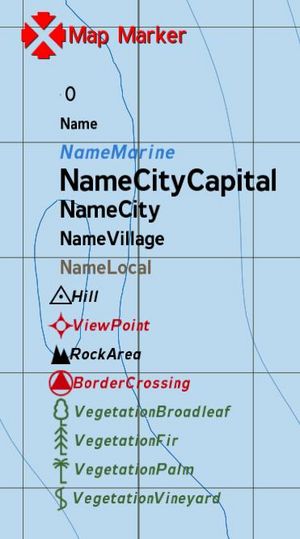
=== | [[File:LocationTypes.JPG|right|thumb|Arma Location icons and fonts]] | ||
=== Armed Assault === | |||
Possible location types are: | |||
* Mount | |||
* Name | |||
* NameMarine | |||
* NameCityCapital | |||
* NameCity | |||
* NameVillage | |||
* NameLocal | |||
* Hill | |||
* ViewPoint | |||
* RockArea | |||
* BorderCrossing | |||
* VegetationBroadleaf | |||
* VegetationFir | |||
* VegetationPalm | |||
* VegetationVineyard | |||
* | {{Clear}} | ||
*NameCityCapital | === Arma 2 === | ||
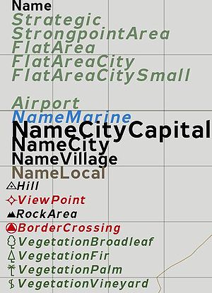
* | [[File:Arma2_CfgLocationTypes.jpg|right|thumb|Arma 2 Location icons and fonts]] | ||
*NameVillage | * Name | ||
*NameLocal | * Strategic | ||
*Hill | * StrongpointArea | ||
* | * FlatArea | ||
* FlatAreaCity | |||
* FlatAreaCitySmall | |||
* CityCenter | |||
* Airport | |||
* NameMarine | |||
* NameCityCapital | |||
* NameCity | |||
* NameVillage | |||
* NameLocal | |||
* Hill | |||
* ViewPoint | |||
* RockArea | |||
* BorderCrossing | |||
* VegetationBroadleaf | |||
* VegetationFir | |||
* VegetationPalm | |||
* VegetationVineyard | |||
== | {{Clear}} | ||
[[File:CfgLocationTypes Arma3.png|right|thumb|Arma 3 Location icons and fonts]] | |||
=== Arma 3 === | |||
* Airport (on Tanoa only. Tanoan airports have their own location type. On Altis and Stratis, airports are '''NameLocal''') | |||
* Area | |||
* BorderCrossing | |||
* CityCenter | |||
* CivilDefense | |||
* CulturalProperty | |||
* DangerousForces | |||
* Flag | |||
* FlatArea | |||
* FlatAreaCity | |||
* FlatAreaCitySmall | |||
* Hill | |||
* HistoricalSite | |||
* Invisible | |||
* Mount | |||
* Name | |||
* NameCity | |||
* NameCityCapital | |||
* NameLocal (will return names like Airport) | |||
* NameMarine | |||
* NameVillage | |||
* RockArea | |||
* SafetyZone | |||
* Strategic | |||
* StrongpointArea | |||
* VegetationBroadleaf | |||
* VegetationFir | |||
* VegetationPalm | |||
* VegetationVineyard | |||
* ViewPoint | |||
* b_air | |||
* b_antiair | |||
* b_armor | |||
* b_art | |||
* b_hq | |||
* b_inf | |||
* b_installation | |||
* b_maint | |||
* b_mech_inf | |||
* b_med | |||
* b_mortar | |||
* b_motor_inf | |||
* b_naval | |||
* b_plane | |||
* b_recon | |||
* b_service | |||
* b_support | |||
* b_uav | |||
* b_unknown | |||
* c_air | |||
* c_car | |||
* c_plane | |||
* c_ship | |||
* c_unknown | |||
* fakeTown | |||
* group_0 | |||
* group_1 | |||
* group_10 | |||
* group_11 | |||
* group_2 | |||
* group_3 | |||
* group_4 | |||
* group_5 | |||
* group_6 | |||
* group_7 | |||
* group_8 | |||
* group_9 | |||
* n_air | |||
* n_antiair | |||
* n_armor | |||
* n_art | |||
* n_hq | |||
* n_inf | |||
* n_installation | |||
* n_maint | |||
* n_mech_inf | |||
* n_med | |||
* n_mortar | |||
* n_motor_inf | |||
* n_naval | |||
* n_plane | |||
* n_recon | |||
* n_service | |||
* n_support | |||
* n_uav | |||
* n_unknown | |||
* o_air | |||
* o_antiair | |||
* o_armor | |||
* o_art | |||
* o_hq | |||
* o_inf | |||
* o_installation | |||
* o_maint | |||
* o_mech_inf | |||
* o_med | |||
* o_mortar | |||
* o_motor_inf | |||
* o_naval | |||
* o_plane | |||
* o_recon | |||
* o_service | |||
* o_support | |||
* o_uav | |||
* o_unknown | |||
* respawn_air | |||
* respawn_armor | |||
* respawn_inf | |||
* respawn_motor | |||
* respawn_naval | |||
* respawn_para | |||
* respawn_plane | |||
* respawn_unknown | |||
* u_installation | |||
[[Category: Data Types]] | [[Category: Data Types]] | ||
[[Category: Introduced with Armed Assault version 1.08]] | |||
Latest revision as of 23:10, 20 November 2023
A location is an extended type of marker. For example city names displayed on the map are locations; their information can be accessed and modified with Location commands.
Location notion was introduced in ![]() 1.08.
1.08.
Specifics
Locations:
- are defined in bin
\Config.bin \CfgLocationTypes / configFile >> "CfgLocationTypes" - have a name, a side, a 3D position, a 2D area, and an orientation
- have a non-scaling map representation (icon and/or text, depending on their class)
- can be attached to objects, with all of the location's relevant properties inherited from the object
- are local, their properties are not synchronised over the network
Terrain built-in locations:
- provide a way to find nearby high points, towns, etc.
- are defined in an island's .pew file. When the island is exported to .wrp its .hpp file is also produced, containing the location names used in the .pew file. This .hpp file is then incorporated into the config for the island using an #include statement.
This section included in the island config ensures any locations set in the .pew file are included in the island during packing.
| Modification | Terrain Location | Scripted Terrain Location using createLocation - Syntax 2 |
Scripted Location |
|---|---|---|---|
| Side | |||
| Size | |||
| Direction | |||
| setVariable/getVariable | |||
| 3D Position | |||
| Attach to an object | |||
| Deletion |
Location Types
Armed Assault
Possible location types are:
- Mount
- Name
- NameMarine
- NameCityCapital
- NameCity
- NameVillage
- NameLocal
- Hill
- ViewPoint
- RockArea
- BorderCrossing
- VegetationBroadleaf
- VegetationFir
- VegetationPalm
- VegetationVineyard
Arma 2
- Name
- Strategic
- StrongpointArea
- FlatArea
- FlatAreaCity
- FlatAreaCitySmall
- CityCenter
- Airport
- NameMarine
- NameCityCapital
- NameCity
- NameVillage
- NameLocal
- Hill
- ViewPoint
- RockArea
- BorderCrossing
- VegetationBroadleaf
- VegetationFir
- VegetationPalm
- VegetationVineyard
Arma 3
- Airport (on Tanoa only. Tanoan airports have their own location type. On Altis and Stratis, airports are NameLocal)
- Area
- BorderCrossing
- CityCenter
- CivilDefense
- CulturalProperty
- DangerousForces
- Flag
- FlatArea
- FlatAreaCity
- FlatAreaCitySmall
- Hill
- HistoricalSite
- Invisible
- Mount
- Name
- NameCity
- NameCityCapital
- NameLocal (will return names like Airport)
- NameMarine
- NameVillage
- RockArea
- SafetyZone
- Strategic
- StrongpointArea
- VegetationBroadleaf
- VegetationFir
- VegetationPalm
- VegetationVineyard
- ViewPoint
- b_air
- b_antiair
- b_armor
- b_art
- b_hq
- b_inf
- b_installation
- b_maint
- b_mech_inf
- b_med
- b_mortar
- b_motor_inf
- b_naval
- b_plane
- b_recon
- b_service
- b_support
- b_uav
- b_unknown
- c_air
- c_car
- c_plane
- c_ship
- c_unknown
- fakeTown
- group_0
- group_1
- group_10
- group_11
- group_2
- group_3
- group_4
- group_5
- group_6
- group_7
- group_8
- group_9
- n_air
- n_antiair
- n_armor
- n_art
- n_hq
- n_inf
- n_installation
- n_maint
- n_mech_inf
- n_med
- n_mortar
- n_motor_inf
- n_naval
- n_plane
- n_recon
- n_service
- n_support
- n_uav
- n_unknown
- o_air
- o_antiair
- o_armor
- o_art
- o_hq
- o_inf
- o_installation
- o_maint
- o_mech_inf
- o_med
- o_mortar
- o_motor_inf
- o_naval
- o_plane
- o_recon
- o_service
- o_support
- o_uav
- o_unknown
- respawn_air
- respawn_armor
- respawn_inf
- respawn_motor
- respawn_naval
- respawn_para
- respawn_plane
- respawn_unknown
- u_installation


